Perhaps one of the most beautiful places in California (and for that matter in the world is the coastal stretch called Big Sur (which means 'Big South' in Spanish)
Big Sur begins just south of Carmel-by-the-Sea and spans many miles South to San Simeon (where the Hearst Castle is located). Carmel may be know because for a while Clint Eastwood was the mayor of that small retirement town and he managed to negate a long held bylaw which made eating an ice-cream cone on the sidewalk no longer a misdemeanor! (This is true)
Carmel-by-the-Sea is also the home of the Carmel Bach Festival, when a group of musicians from many areas congregate and celabrate the music of J.S. Bach.
Carmel can be described as "charming" that says it all- houses with "cute" names, some built like gingerbread houses, others like small castles, etc.(Sorry no pictures! :-))
As a child, I spent a lot of time in Carmel and managed to survive the icecream law/dilemma.
I spent MUCH MORE time in Big Sur, as a child and for years afterwards.Big Sur is an incredibly dramatic and spectacular location...where the steep mountains blend into a deep erratic and strong ocean with enormous waves.The norm was to wake up to dense fog which would clear completely by noon giving rise to a clear blue sky, and very comfortable temperatures.
When I was a child, almost all of the beaches were inaccessible to the general public since the land surrounding them was privately owned; this was good and bad-being unfair to those who wanted to visit the very isolated beaches; however, the government is now on a "rampage" to make all of the beaches public and although most treat these beaches with respect, there are a small number who "trash" the beaches and now many that were so "untouched" are now sadly full of garbage.
Point Lobos (Point "wolf"-I'll'have to make sure of the translation-Spanish) is one haven that the government has kept protected and one is not even allowed to pick a piece of grass without serious consequences (legal).
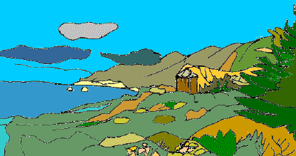
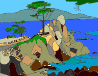
Prior to the allowing public access to many of the beaches south of Point Lobos, one could find actual Gold Nuggetsas well as many arrowheads and burial grounds left by the original settlers the native Indians!You know it's coming... Here is a picture of some land that let us access a beautiful beach (which now has become public)
The brownish structure was a very old water tower.The picture shows a view looking North; to the West, there were remnants of the original highway 1 (Built by the people in the Gold Rush There was also a pond that originally had Carp (large goldfish) but earthquake activities caused the bed of the pond to crack and under the water has been preserved an Indian burial ground!
Big Sur originally was settled by people who were in the arts-all kinds; painters, writers (eg. Henry Miller, Jack Kerouvac, etc.) and other famous artists.
Further South on Highway one, there is a famous restaurant by the name of NEPENTHE which is symbolized by the phoenix...
The original restaurant building was constructed by Bill and Lolly Fassett in the 1940's.
Prior to that, Orson Welles had owned the property when there was only a log cabin.
The log cabin was where Bill and Lolly Fassett resided during the time that they were building the restaurant that is now known as Nepenthe
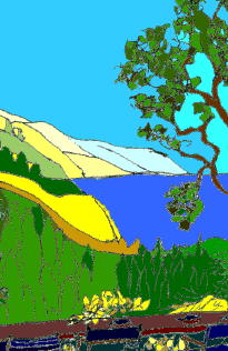
Here is a picture of the view looking South from Nepenthe:
 The Monterey Cypress is endemic to this area of California; These trees form groves through which runs the Seventeen Mile Drive the beautiful winding road that spans between Carmel and Monterey.
Of note is that one point called "Point Joe" (along the seventeen mile drive) is the site of many ship wrecks because in the past, many sailors mistook Point Joe for the entrance to Monterey Bay (But Point Joe consisted of dangerous rocks)
The famous Pebble Beach golf course is located along the seventeen mile drive.
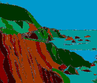
The following "pictures" depict certain landmarks along Highway one through Big Sur...This is taken from the roadside and shows the scenery looking south: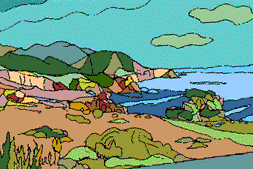
Using your imagination, one can see the ruggedness of the coastline...completely different from the placid coastlines in the Caribbean; due to the incredible power and force of waves/tides causing extensive erosion.
Beyond the Southernmost point, the highway courses inland and the scenery becomes different, since one is driving through dense forests of giant redwood trees (Not shown)[:-(]
The next picture shows the remarkable array of colors that are evident during certain seasons, usually due to the great variety of wildflowers (actually Poppies-See later)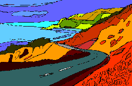 This specactular view very closely approximates the true colours of the actual photograph.
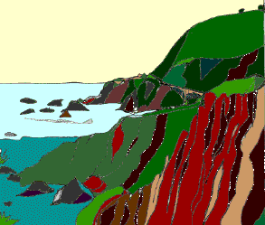
The photograph was taken at a point very close to the location of the previous picture but this shows the view looking North (towards Carmel).One can notice the very winding road; this highway was quite dangerous and there were frequent accidents.
This picture illustrates the very famous "Bixby Creek Bridge". Click Here to go back to top. Click HOME to go to main page. Click HERE for the West Indies. Click Here for a description of California's sea life. Click Here For info on S.C.U.B.A. diving. Click HERE to see some frames! Click HERE for Java. Click here for details on tidepools. Click HERE to send me email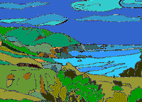
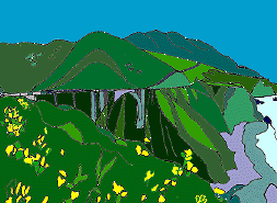 The bridge spans the Bixby "Creek" which was more like a torrential river...The river mouth opened into the ocean seen on the lower right.(almost)What IS evident are the multitude of yellow/ orange flowers which are meant to be the California Poppy" (Please see a future link)The significance of the California Poppy, is that being the state flower one CANNOT pick them (since they are protected) without serious legal ramifications. (Much more serious than eating an ice-cream cone on the streets of Carmel)