|
| |
Kanu  Links Links
The LaVase Portages:
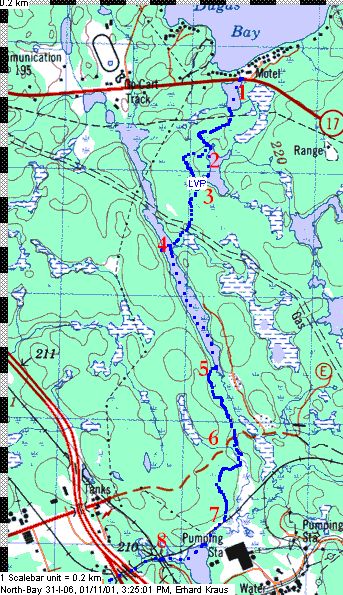
Dugas Bay to La Vase River
- N 46.30224°, W 79.38466 °
Put-in beside Highway 17, at the historical plaque and parking lot beside
Brandy Lake. Paddle to the lake's south end and start portaging at the base of two large
spruce trees.
Carry for 484m to pond.
- N 46.2978 °, W 79.38778 °
There, you may paddle across or, at low water, carry for 665m through the woods and
over a rocky ridge to join the next portage trail. Both GPS tracks (water as well as land)
are indicated on the map.
- N 46.29542°, W 79.38849 °
Portage 620m to the long lake. About 2/3 along, you will cross a field that hides a
buried pipeline.
- N 46.29098°, W 79.39152 °
The portage ends at a muddy creek. At high water, put in there and paddle to beaver
dam which spans the lake there and lift/slide over on left side. At low water, carry
over creek and over low hill to put in below beaver dam.
Paddle the length of the swamp/lake for 1 km.
- N 46.28201°, W 79.38711 °
About 30m from its end, take out on right shore and enter the forest for the
1800m portage to the LaVase river.
The historic portage was located on the east side of the creek but was obliterated
in the early 1970's. A full-scale quarry operation sits directly on the trail today.
Today, the route goes through about 300m of alder bushes before a vague
trail reappears. Do not attempt to re-enter the creek at the road as the area is
off-limits due to federal restrictions around the chemical plant's perimeter
- N 46.27709°, W 79.38523 °
About 700m into the portage, it crosses a quarry road at right angle, then heads
SW, goes across a beaver pond/dam, rises up over a granite hill and drops down towards the
railway line. In most of this section, the trail is hard to make out, and the GPS will
come in handy.
- N 46.27108°, W 79.38625 °
Cross railway tracks (extreme caution, the rail line is in heavy use. Let
your partner look out for trains while you carry the canoe across the tracks) and
launch on the LaVase River. You are now on a small lake beside the Fabrene Plant (labeled
"Pumping Station" on the topo map), just above the railway bridge.
Continue... |
|
Note about the map:
 | Copyright: Extract of the data sets
North Bay_31I06 at 1:50,000
©Her Majesty the Queen in Right of Canada
Reproduced with the permission of Natural Resources Canada
|
| The maps were produced with QV Touratech using the topomaps from QuoVadis. - Links |
Back to the LaVase Portages Page
|